Cartography And Mapping With Surfer
MP4 | Video: h264, 1280x720 | Audio: AAC, 44.1 KHz
Language: English (US) | Size: 768.77 MB | Duration: 1h 25m
Maps 101 : Beginner to Advanced
What you'll learn
Getting to Know Surfer
Creating maps with XY points
Editing Raster (image) and Vector Base Maps
Interpolating Data (Gridding Data)
Contour Maps
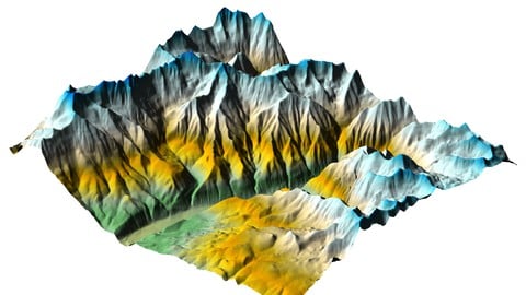
3D Surface Maps
Slicing Through Raster Grid Layers with Cross Sections
Raster Grid Operations: Grid Mosaic
Raster Grid Operations: Grid Math
Raster Grid Operations: Assign No Data
Raster Grid Operations: Grid Volume
Real World Workflow Examples
Requirements
Computer
Description
Surfer or Golden Software Surfer is one of the top softwares used by different Geoscience industries to create maps and to do cartography. it can be defined as a Gridding , Contouring and surface Mapping software. Surfer can be used to Visualize Data, Analyze Data and communicate the results in the form of 2D or 3D maps or sections. In this Training we are going to take have an overview about how the software works and how you can use it as a GIS tool to create different types of maps and how to use the built-in tools to do various tasks.
Who this course is for
GIS students,Geologists,Mining engineers,Geoscience students

without You and Your Support We Can’t Continue
Thanks for Buying Premium From My Links for Support
Click >>here & Visit My Blog Daily for More Udemy Tutorial. If You Need Update or Links Dead Don't Wait Just Pm Me or Leave Comment at This Post
Quick check before we show the links
Helps us keep automated scrapers from hammering the filehosts.